Showing posts with label UK. Show all posts

Friday, October 25, 2019

3 Perfect Days in North England and North Wales, UK

The United Kingdom (UK) is a union of England, Scotland, Wales and Northern Ireland. The island of Great Britain (GB) has England, Scotland, Wales. It is hard for many people to differentiate between UK and GB. A trip to GB is a good way to immerse oneself in the scenic beauty of England and Wales. The North of England and Wales are famous for their natural beauty. National parks with green rolling hills are prime destinations for camping and hiking. The valley in between hills, lakes and cute little villages are retreats for the tired soul.

Day 1: North Wales - Snowdonia National Park & Llanfairpwllgwyngyll
Swallow Falls Waterfall
Swallow Falls - Snowdonia National Park
Llynnau Mymbyr

Llynnau Mymbyr From A4086 - Snowdonia National Park
 Snowdon ViewPoint
Peak, Lake, and A Valley - Snowdon Viewpoint
Llanfairpwllgwyngyll Village

Day 2: North England - Peak District
Upper Windleden Reservoir
 Winscar Reservoir
 Ladybower Reservoir
 Snake Road
Day 3: North England - Lake District
Lake Windermere
Rydal Water
Grasmere
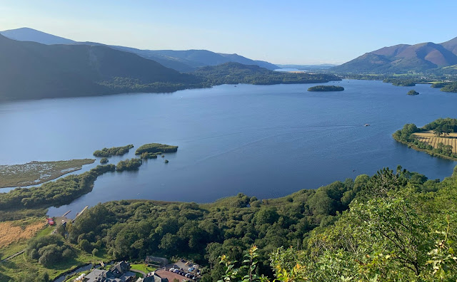
Surprise View
Ashness Bridge

Friday, September 6, 2019

A Perfect Day in Snowdonia National Park, UK

Snowdonia National Park is by far, the best national parks I have ever visited. The landscape is breathtakingly beautiful. It is a perfect destination for outdoor activities like walking, hiking, camping, and many more. If you are short on time, just drive around the national park and stop to soak in the views. Snowdonia National Park covers around 2135 square kilometers. Given the vast area, it is impossible to cover the entire national park in one day. Here are the few locations that are accessible by road and can be covered in a day. The starting point of this trip is from Liverpool.
Swallow Falls - Snowdonia National Park
Swallow Falls Waterfall: The waterfall is located right across A5 and does not involve strenuous hiking or walking. It is just 2.5 miles from the village of Betws-y-Coed and can be reached by car or on foot. A nominal fee of £2 is charged at the entrance. Make sure to carry cash in Pounds as no other currency is accepted. A paved pathway leads to the beautiful cascading waterfalls surrounded by lush forest. Nearby rock stairs lead to different levels for better views.
Llynnau Mymbyr From A4086 - Snowdonia National Park
 Llynnau Mymbyr: On A4086, 0.5 miles away from A5, lies two beautiful lakes of Llynnau Mymbyr. It is a perfect scenic location. You can park the car and take a short walk or be a bit more adventurous and go parasailing, hiking or kayaking. No matter how you choose to explore, this place is a feast for the eyes. Probably, this is the most photographed lake in all of Snowdonia.
Beautiful Views From A4086 - Snowdonia National Park

Peak, Lake, and A Valley - Snowdon Viewpoint
Snowdon Viewpoint: Proceed on A4086 for a couple of miles and continue towards A498. You would come across an undeniably best viewpoint and that would be Snowdon Viewpoint. Snowdon Peak, a valley and a lake, a perfect location for a photoshoot.
Snowdon Peak: There are two options to reach the Snowdon summit. One is to hike the peak and the second is to take a train from Llanberis Station. Be sure not to confuse Llanberis Station with Llanberis Lake Railways. Getting to the summit is still on my to-do list. Unfortunately, we were not able to procure train tickets for the summit. Tickets to the summit can be prebooked. The total trip takes around 2.5 hours. One hour to ascend, one hour to descend and half an hour to explore the summit. For travelers who wish to hike the peak, the Miners' Track and PyG Track start from Pen-y-Pass car park on A4086. Roundtrip on either track takes around 6 hours. However, the Miners' track is popular among hikers and is well known for its beautiful views.
Ceunant Mawr Waterfall: A beautiful waterfall accessible from A4086. The waterfall is very near to Llanberis village. It would take around 10 minutes to reach the waterfalls from the village. There are two paths to reach the waterfall. The marked path takes you to the top of the waterfalls. An unmarked path that passes under the stone bridge leads you to the bottom of beautiful waterfalls.
Pont Pen-y-Llyn: Pont Pen-y-Llyn is a viewpoint very near to Brybrefail village and is accessible from A4086. A beautiful view of lake Llyn Padarn with mountains as a backdrop. Stop by for a quick walk across the bridge. There are several watersports and activities on the lake. 
Llanfairpwllgwyngyll Village:  
Llanfairpwllgwyngyllgogerychwyrndrobwllllantysiliogogogoch is the name of a village in North Wales. With 58 letters,  this village name is considered the lengthiest one-word name in the world. There is nothing in the village to see or do. James Pringle Weavers have a better sign with English translation. James Pringle's store is full of trinkets and souvenirs.

Saturday, December 29, 2018

Causeway Coast, Northern Ireland, UK

Officially Nothern Ireland is a part of the UK. Causeway Coastal Route stretches from Belfast to Derry~Londonderry. As of now, there is no hard border between the Republic of Ireland and Northern Ireland so there is no border control, passport checks, etc. You can drive between these two countries and wouldn't even notice crossing one country to the other. Northern Ireland (NI) is best visited during the summer months. Despite detailed planning, we couldn't make it during the summer months. However, in September, we got to spend a fabulous weekend in Northern Ireland. A day visiting Antrim coast and another day in Belfast. Click here for the trip ideas.
Weather on islands, in general, is very unpredictable. Even forecasts end up being an approximation. Whether forecast projected sunny and clear skies on the day of our visit. On the contrary, it was stone cold with strong winds and cloudy skies. The spellbinding views were worth the trouble. No matter how much I write in this post, I wouldn't do this place a justification. Just hop in a car and drive. You have to be there to see it. All I can say is 'Don't miss it'. We drove from Belfast to Dunluce castle and followed the Coastal Route back to Belfast. In a day, we were able to visit Dunluce Castle, Giant's Causeway, Carrick-a-Rede Rope Bridge, Dark Hedges and stop for a few quick photos along the Causeway Coastal route. 
Carrick-a-Rede Rope Bridge:
View From The Rope Bridge

Carrick-a-Rede Rope Bridge

Spellbinding Views

Game of Thrones Location Near The Rope Bridge. Also Used As Car Park
Giant's Causeway:
Giant's Causeway
I came across Giant's Causeway in a kid's encyclopedia. The Giants Causeway is a result of an intense volcanic and geological activity. This is a UNESCO world heritage site with 40000 interlocking basalt columns. The interlocking basalt columns are a result of cooling and shrinking of successive lava flows.

 
How Do I Explain This????
A new state-of-the-art visitor center is energy efficient and has a grass roof. This is where the science and the stories come to life. Walking tours and audio tours start from the visitor center. With a nominal price, a shuttle bus runs from the visitor center to and from the Causeway.
And This???
There are four trails for visitors to choose from. All of them are color-coded and have beautiful views of the Causeway. Green Trail is the easiest of them all.  While Blue Trail takes you to The Camel, Giant's Granny, and is moderately difficult, Red Trail and Yellow Trail are challenging. All the cliffs and Causeway routes are unfenced, slippery, and are accompanied by high waves, strong winds, and cold temperatures. Please maintain caution at all times.

Causeway Coastal Drive:
Sheep Island
Carrick-a-Rede View From Far
Dunseverick Castle Ruins
Sheeeeep!!!!!!

Dark Hedges:
Game of Thrones Location
Dark Hedges